
Weather Station Installed on Pokagon Band Tribal Properties - Pokégnek Bodéwadmik Dbë'gnen
![]()
![]()
Installation of the weather station within the Tribal Soil Climate Analysis Network (TSCAN) began in early November of 2021. Over a few visits during November, Kowabdanawa odë kė worked with NRCS and the Cass County Conservation District to install the new weather station on tribal properties.
Kowabdanawa odë kė also worked with Ėthë Bodwéwadmimwat to come up with a name for the TSCAN weather station: Pokégnek Bodéwadmik Dbë’gnen – Pokagon Band Measurements. The TSCAN weather station will assist in taking weather measurements, including wind speed and direction, solar radiation, relative humidity and temperature, rain amounts, snow amounts, and soil moisture and temperature.
The data from the station that are provided to the network can be utilized by anyone interested in finding out more information about the local weather. The Pokégnek Bodéwadmik Dbë’gnen weather station will be able to assist with monitoring climate change effects and will assist agricultural producers, so they have better knowledge of when to plant their crops.
Pokégnek Bodéwadmik Dbë'gnen (3071) - Site Information and Reports
Environmental Quality
Kowabdanawa odë kė's Environmental Quality Division (EQD) will develop and implement regulatory programs based on Section 2.04 of the Health and Safety Act. Many of the rules and regulations that are addressed in Section 2.04 are based on federal environmental statutes that the U.S. Environmental Protection Agency (EPA) is responsible for administering. Thus, the EQD will function similarly to the EPA.
Pesticide Management
Do you have a Pesticide or Fertilizer Complaint you would like to file?
If so, please download this form, fill it out and return it to Kowabdanawa odë kė.
Complaints regarding pesticides and fertilizers need to be submitted promptly to consider incidents before the contaminants are no longer present. Complaints received more than 30 days post-incident will be kept on file, but no action will be taken.
Water Quality Program
The Water Quality Program, run by the Water Quality Specialist, is the first of many programs that will be needed under EQD. The program aims to protect, assess, and restore water resources on tribal lands. The water program will consist of Baseline Monitoring, Watershed Base Planning, and ordinance and regulation development.
Program Highlight
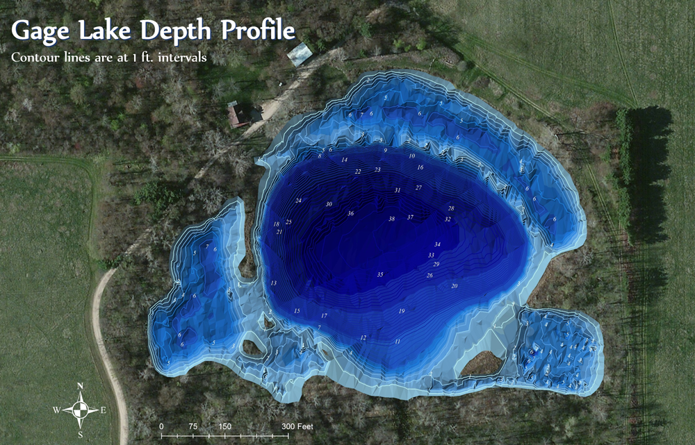
Kowabdanawa odë kė has created a depth profile (bathymetry) map of Gage Lake. Using a Sontek RiverSurveyor, 12,000 + points were collected over a 5-hour time period. The data collected was then entered into ArcGIS software to create the map. Profile contours are in 1-foot intervals and show a maximum depth of 38 feet for Gage Lake. This information will help citizens see the lake's depths and assist in selecting the fishing site. This information will help the DNR during their water sampling efforts and also assist with additional modeling that may be completed regarding Gage Lake in the future.
Current Activities
Baseline Monitoring of Surface Waters
- Develop and implement the Band's water monitoring plan on lakes, rivers, and streams that are on and/or adjacent to Tribal lands
- Prepare a Clean Water Act 106 funding application to EPA. The EPA 106 program assists eligible tribes and states implement water quality monitoring and protection programs.
- Assess the Band’s surface waters to see if they are in compliance with Pokagon Band water quality standards. Pokagon Band water quality standards were adopted via the Pokagon Band "Health and Safety Act," in which Michigan's Natural Resource and Environmental Protection Act (NREPA) is the reference.
Watershed Base Planning
- Attend local watershed meetings and communicate Pokagon Band concerns and goals of local waters resources
- Contributing to the development of St. Joseph, Paw Paw, Dowagiac, and Galien River watershed plans
- Implement the plans and Pokagon Band water resources goals via restoration projects, monitoring, education, and partnerships.
Ordinance and Regulation Development
- Review and assess current ordinances and regulations
- Assist with the creation of water protection-related ordinances and regulations
- Develop water quality standards that are federally recognized and meet Pokagon Band's water resources needs
Reference links
Watershed Plans: St. Joseph River, Paw Paw River, Dowagiac River, Galien River
Pokagon Band: Health, Environmental Protection and Building Codes Act
NREPA: Natural Resources and Environmental Protection Act